
![]() Download Airborne FEM Product Description
Download Airborne FEM Product Description
![]() Download Ground FEM Product Description
Download Ground FEM Product Description
Download Airborne FEM demo database
(works with our EMIGMA Demo)
The FEM software package includes airborne and ground FEM and is available as an add-on to other EMIGMA Premium licenses or as a standalone product.
In the airborne FEM method, the transmitter and receiver coils are generally housed in a single case and are towed by a helicopter. Airborne FEM offers the advantage of collecting large amounts of data over a relatively short period of time. Being not limited by the geophysical survey size, EMIGMA allows rapid airborne FEM modeling and inversion. EMIGMA is an excellent tool for survey design as well as for interpreting measured data.
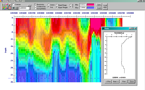
The package offers very good routines for calculating apparent resistivity as well as an adaptation of the Sengpiel section techniques. EMIGMA also allows you to process your FEM data (ground and airborne) through several 1D inversion tools and produce these as conductivity depth sections relative both to ground level and to actual GPS elevation.
Unlimited Survey Size!
Data Import
- Calibrated data imports from ASCII files or manufacturer's format, such as Ground Geonics EM31/34/34R/38, Max-Min, Geophex. Generally any dipole-dipole type system can be imported.
Data Processing and Correction
- 1D digital and spatial filters, 2D spatial filters
- Simple and weighted averaging decimation
- Data Corrector tool combining dynamic spreadsheets and line plotter for data cleaning, missing data interpolation and simultaneous plotting of different data channels for fast cross-analysis
- Profile Modifier Tool - Access your data from a survey perspective, edit your survey, create maps, clean your data
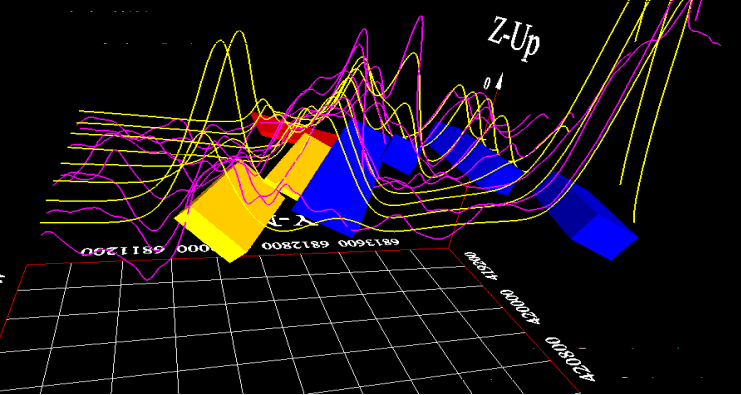
3D Modeling
and EM modeling with
data overlays
- Fast and accurate 3D simulations: model suite generation and batch mode
- Unlimited prism, plate and polyhedra targets
Polyhedra: pipes (hollow cylinders with or without lids), ellipsoids, shells, bullets, landmines, drums, spheres, general polyhedra... - Multiple body interactions
- Modeling of topography effects
- Modeling of magnetic effects in EM data
- Ability to handle full contrast between host and bodies
- Incorporation of altitude information
- Interactive 3D model building tool
1D Inversion
- Multi-Component and/or Multi-Frequency inversions, Inphase/Quadrature or Quadrature only
- Three algorithms to choose from
- Smooth Occam resistivity inversion with fixed layer thickness
- Smooth Occam joint susceptibility/resistivity inversion with fixed layer thickness with user defined starting models
- Underparametrized Marquardt Inversions - invert for thickness and/or resistivity
- User defined starting models
- User defined parameters for inversion
- Full resistivity and thickness constraints
- Spatial smoothing capabilities
- Suite of minimization techniques
- Incorporation of GPS_Z information
CDIMAP
- Apparent Resistivity Tool - a half-space mapping technique for generating apparent resistivities as a function of frequency
- Sengpiel Depth-Sections - a resistivity pseudosection technique for generating resistivities as a function of pseudo-depths
Data Display and Analyses
- Display of data over flight altitude variations, GPS positions
- Display of Apparent Resistivity as a surface or spatial contour
- PEXShow tool - 2D representation of geoelectric sections
- Display of 3D models sliced and diced in the 3D Visualizer
- Grids: Natural Neighbor, Delauney Triangulation, Shepard & True-to-Data, Minimum Curvature and Thin-Plate-Splines
- Contours: 2D and 3D surfaces
- Line plots
- Residual plots
- For more detailed data display capabilities, see EMIGMA Complete
Data Export
- Export to postscript files, raster or GeoTIFF formats
- Export to XYZ ASCII file (containing station, position, depth and apparent resistivity) to allow for the geoelectric sections to be utilized in other plotting or printing applications such as Geosoft or Surfer