
Download Near Surface demo database
(works with our EMIGMA Demo)
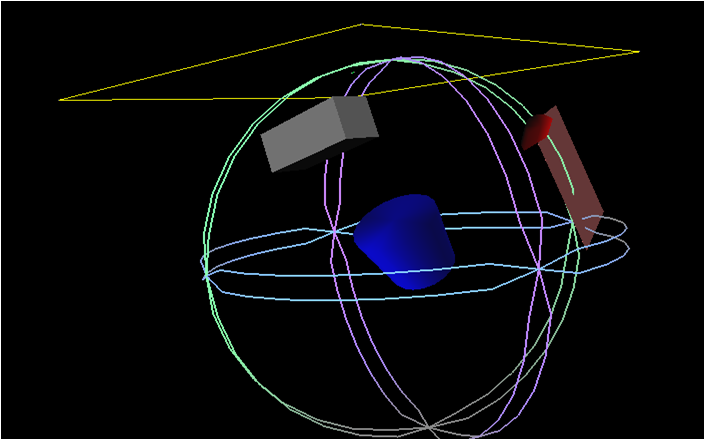
Click image to enlarge
3D Modelling
Magnetics, FEM, TEM, Resistivity, Gravity
Up to 50,000 points
GUI Interface - Intuitive User Interfaces for Windows 2000/XP/Vista/7
Data Imports
- Large Loop TEM Imports (Geonics, Zonge, UTEM and Crone)
- Small loop systems (terraTEM, TEM-FAST, Phoenix TEM and WTEM)
- FEM Imports (Ground)
- AMIRA TEM (Geonics, Crone, SIROTEM)
- Time Domain IP (Zonge, ELREC6 format or as an ASCII text format)
- Frequency Domain IP (Zonge and ASCII text format)
- Resistivity Data (Generic ASCII text file) with Phase if available
- Gravity Data in XYZ or QCTool format
- Magnetic Data Gradient data, vector data in XYZ or QCTool format
Data Management
- Database backbone
- Large data set handling: three levels of data organization inside a database
- Merging, export, import of data sets and their customization for further use in EMIGMA modeling
- Data statistics
Data Processing and Correction
- 1D and 2D digital and spatial filters, with sizes specifiable by the user
- Simple and weighted averaging decimation
- FFT tools for magnetic data applicable to both measured and simulated data
- Graphical data extraction, profile editing and modification
- Data Corrector tool combining dynamic spreadsheets and line plotter for data cleaning, missing data interpolation and simultaneous plotting of different data channels for fast cross-analysis
- Magnetic base station correction
- Latitude/Longtitude projections including polar projections
- Average duplicates, remove outliers, merge lines or surveys
- Trend removal
3D Modeling
- Easy model building: large data sets, flexible profile generation and manipulation, multiple system geometries, large loop modeling, etc.
- Unlimited plate, prism and polyhedra anomalies suitable of EM, Magnetic, Resistivity, Gravity data
- Multiple target shapes: pipes (hollow cylinders with or without lids), ellipsoids, shells, bullets, landmines, drums, spheres, prisms, plates, general polyhedra...
- Multiple scattering modeling: Simple Superposition, Far- and Near-Field Interaction, Automated Mode (the type of interaction is selected for you)
- Synthetic Topography-Poly Generator for modeling complex geological anomalies and topography
- Modeling conductors with volume ILN prisms - Volumetric Induction Modeling
- Model suite generation for rapid building of layered earth and plate model suites with varying resistivity, thickness, strike, strike length, dip, dip extent, plunge and conductance
- 3D forward simulation in batch mode: multiple sources, any number of profiles, any number of data components
- Import of geological models from CAD applications
- Model building tool in 3D space
Data Inversion
- 1D inversion for EM and Resistivity data
- 3D inversion for Magnetics and Gravity including topographic effects
- Display of 3D model section cutting in the 3D Visualizer
- 2D representation of geoelectric sections - PEXShow tool
- Magnetization vector inversions
3D Euler Deconvolution
- Statistical and Rodin post-processing
- 2D and 3D visualization of solutions
2D and 3D Visualization
- Data visualization in 3D space, as profiles, vectors, true 3D surfaces or contoured surface along with the 3D structure display
- Ability to view up to three data channels
- 3D modeling tools: easy object manipulation and adjustment, single-click conversion of prisms to polyhedra, etc.
- 2D and 3D visualization of Euler solutions and magnetic inversion results
Plotting
- Comprehensive XY Plotter for plotting data, decays and positions
- Multi-channel and multi-profile plotting
- Flipping between resistivity and conductivity
- Switching between channels, profiles and models
- Plotting to scale
- Multiple plots per page
- Residual plotting
- Saving plotting defaults for rapid plotting of model suites
- FOM algorithm for data quality control
Gridding
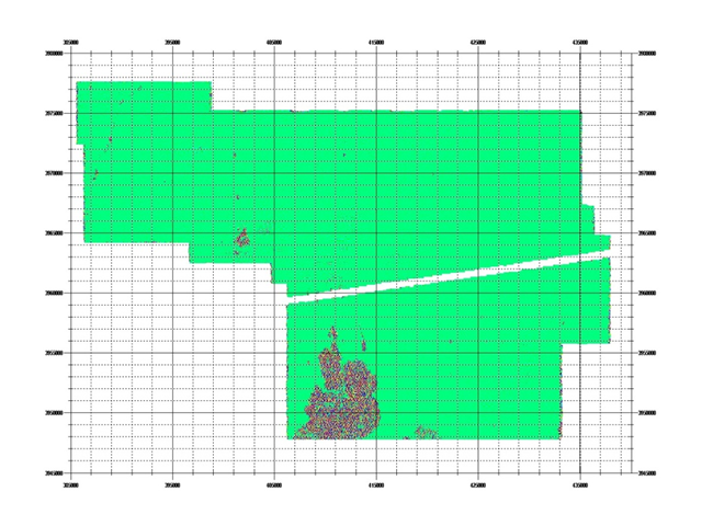
Click image to enlarge
Gridded Data
- Five gridding algorithms: Natural Neighbor, Delauney Triangulation, Shepard & True-to-Data, Minimum Curvature and Thin-Plate-Splines
- Quick setting of your grid geometry and input data to be used for interpolation - ProfileViewer
- Residual grids
Grid Presentation and Analysis
- Multi-component grids - switching between channels and components without a necessity to grid anew each time
- Rectangular grid cells
- Profile, data and contour overlays
- Equal Weight and Equal Range display
- Single-click conversion to Apparent Resistivity and Conductivity
- Analytic Signal displays
- Euler solution overlays
- Decay rate/Amplitude mapping and export
- Superposition on raster maps and annotation
- Map generation with options for transparency and annotation
- Import and export of GeoTIFF format
- MultiGrid tool - viewing and comparing up to 4 grids at a time
Contouring
- OpenGL interpolation
- Multi-component contours - switching between components and channels
- Flipping between Apparent Resistivity and Conductivity
- Contour lines and their customization
- Data display as 3D surfaces
- Range of pseudo-depth and pseudo-section displays
- 3D volume interpolation of inversion results - section cutting