
Download Gravity demo database
(works with our EMIGMA Demo)
The Premium package supports Ground, Airborne, Marine and Borehole data. The license may be purchased standalone or combined with other licenses.
QCTool
- Drift corrections
- Tidal Corrections
- Latitude correction
- Free-Air correction
- Bouguer correction
- Data averaging ( simple or bootstrap techniques)
- Correction for absolute gravity measurements
- Terrain correction (feature) supports:
- Import of regional DEM from the USGS ( 1km grids)
- Import of higher density DEM grids such as U.S. state grids, Canadian topographic grids,
Mexican state grids and Australian grids - Local (terrain) correction option for small grids
- User-specified topographic file formats. Please email us for more info.
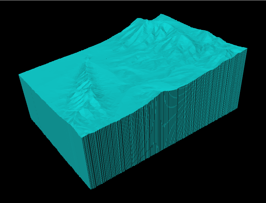
- Topographic corrections are done using latest techniques as follows:
- Topography grids are used to produce a 3D topographic surface
- 3D topographic surface is split into tetrahedral cells
- Each cell's gravity contribution is computed by accurately integrating over the volume grid cell(topped by the 3D surface)
- Improved accuracy for large cells or areas with significant relief compared to
the traditional approach
- 1D, 2D spatial and digital filters
- Eötvös correction (for marine and airborne data) - NEW FEATURE
- Isostatic correction - NEW FEATURE
EMIGMA
After importing the processed data in EMIGMA, the user can take advantage of its advanced gridding and modeling features as well as state-of-the-art inversion techniques.
EMIGMA's gridding features include rectangular grid cells with user-selected aspect ratio for irregular survey points. Also, it allows for the creation of a suitable FFT grid, which is then used to perform a host of advanced routines such as tapered Tukey filtering, first, second and higher-order derivative calculation, upward/downward continuation and wave number/ wavelength filtering.
Furthermore, EMIGMA's enhanced modeling capabilities include:
- Importing of topography files
- Importing simple and complex polyhedra files from CAD or AutoCAD modeling
- Model export to .dxf (AutoCAD), .asc (Vulcan) and .str (Surpac) formats
- Map import and export to GeoTIFF, DXF (AutoCAD) and KML (Google) formats
The package also includes a Forward Simulation (often referred to as 'forward modeling') feature, which offers robust algorithms to simulate the gravity response. Two algorithms are provided, one utilizing the traditional Numerical Integration method and the much faster and more accurate Analytic method.
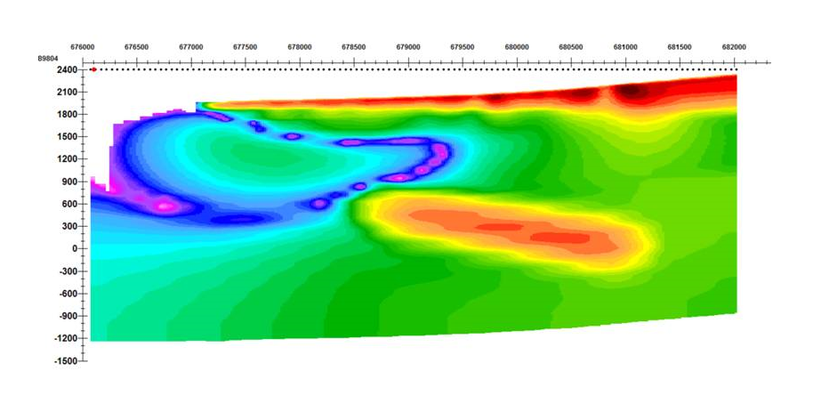
EMIGMA's 3D inversion is by far, the most powerful feature of the package. The inversion methods allow the user to invert not only the measured data but also the processed FFT-data.
Three algorithms are provided:
Linear Fast CG (Matrix)
Linear CG (Matrix)
Non-linear CG (iterative model search)
All techniques allow rectilinear cells with user-chosen dimensions, arbitrary grid azimuth, and varying cell thicknesses with depth.
For a detailed description of the inversion techniques and other features, please download the product description (PDF).
EMIGMA for Gravity is now also available as part of EMIGMA Premium Complete, as a standalone product or as an add-on to other EMIGMA Premium packages.
Comprehensive Software for a very economical price!
Unlimited number of survey data points (airborne, marine)!
Suitable for Ground, Airborne, Marine and Borehole data!
Extensive built-in support through 'Help Topics' and 'Tutorials'!
User-friendly and intuitive interface!

Data Import
- ASCII format (.xyz, .txt), including full tensor gradients
- Instrument formats (manufacturer specified)
- QCTool format (.qct)
- Geosoft grid file (.grd)
Data Processing and Correction
- Basic corrections through QCTool:
- Drift, latitude, free-air, Bouguer, terrain/topography and tidal
- Eötvös correction now available - NEW
- FFT-processing tools include:
- Wavelength/wave number filtering
- Upward/downward continuation
- Derivative calculation
- 1D, 2D spatial digital filters
- Data Correction tool (enhanced features for editing and processing data)
- Survey Editor (2D-viewer for editing or planning surveys)
Data Display and Analyses
- Gridding with 5 algorithms: Natural Neighbor, Delauney Triangulation, Shepard & True-to-Data,
Minimum Curvature and Thin-Plate-Splines - 2D and 3D contoured surfaces
- Displays gridded data including Analytic Signal and Horizontal Analytic Signal derivatives
- Supports export to raster and Georeferenced formats including KML and DXF
- 3D contour display
- Displays gridded data as a smooth 3D surface
- Export to raster and 2D/3D vector formats supported
- Line plots and data Residual Plots (2D Plotter). The most sophisticated geophysical plotting tool available.
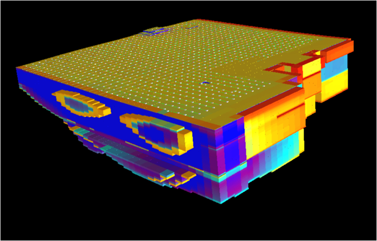
- 3D Visualization
- 3D model building and visualization with associated measured and simulated data
- 3D visualization of 3D inversions and Euler solutions
- Inversion slicing and exporting of slices
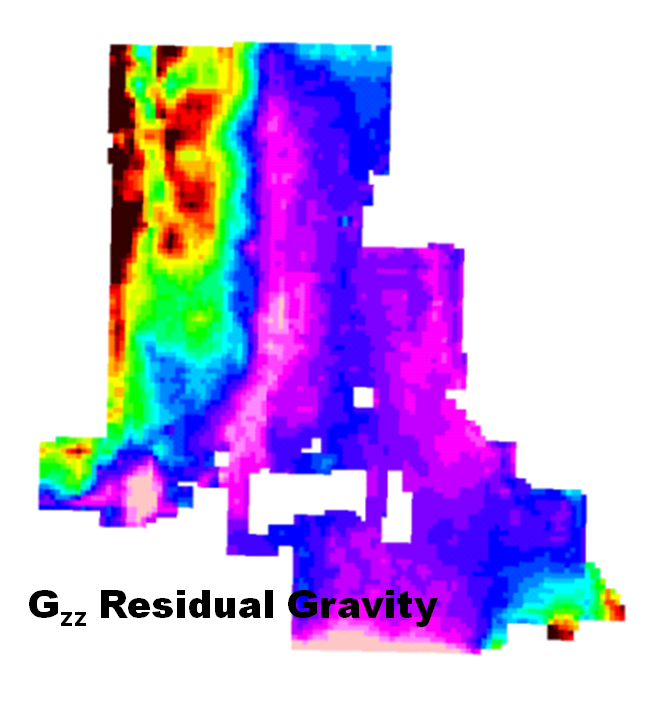
Gradients
- Derivation of FFT gradients
- Leveling with vertical gradients
- Enhanced contouring with horizontal gradients
- Modeling of gradients and inversion using gradients
3D Modeling
- 3D Visualizer
- Modeling of large data sets
- Geophysical model building tool in 3D space
- Unlimited prism and polyhedra targets
- Import of polyhedron objects using DXF (AutoCAD), ASC (Vulcan), TRI (Surface Mesh) formats
as well as Poly (.xyz) and QCTool grid (.egr) formats - Easy export to DXF, ASC and STR (Surpac) formats
- Fast and accurate 3D simulations using:
- Advanced algorithms
- Model suite generation options, batch mode simulation and 'Noise Range' features
- Topography effects
- Supports import and modeling of topographic files in ASCII column XYZ
and QCTool grid (.egr) formats, thus allowing for non-uniform density effects of topography
- Supports import and modeling of topographic files in ASCII column XYZ
3D Gravity Inversion
- Improved constrained inversion techniques employing both measured and processed derivatives
- Sensitivity to geology and topography effects
- Post-inversion removal of grid cells NEW FEATURE
3D Euler Deconvolution
- 3D Extended Euler solutions for profile and gridded data
- Post-processing with 2D and 3D visualization